
")


The Samekh (Fish) Riverbed
The Samekh Riverbed (Samekh means “fish” in Arabic) is one of the longest riverbeds in the Golan, with such impressive cliffs that some even call it the “Mini-Grand Canyon of the Golan.” The origin of the stream is a group of springs next to the Shaabaniya Ruins (about 3 kilometers southeast of Moshav Yonatan). The Revaya Reservoir, built on the banks of the riverbed, collects some of the rainwater flowing down towards Lake Kinneret, and is used by local farmers for irrigation. The riverbed carves a deep path into the basalt layers, and reveals layers of white limestone underneath the black rock. The length of the riverbed is 20 kilometers, and water flows through it all year long (not a common occurrence in Israel). The Samekh Riverbed empties into Lake Kinneret near Kursi Junction.
Two segments of the Golan Trail go through the riverbed:
Segment 10, from the Daliyot campsite to Ein Keshatot (10 kilometers).
And segment 11, from Ein Keshatot to the T’ayna Riverbed (9 kilometers).
The Golan Trail is a hiking trail that was established in 2007. The 120 kilometer-long trail is based on a north-south axis, and is located on the eastern side of the Golan. It stretches from Mt. Hermon in the north to Mevo Hama in the south, and is split-up into 15 segments.
Interesting sites along the riverbed:
The Syrian Bridge on the Diversionary Canal
The Syrian Bridge of the Samekh Riverbed was built out of cement and basalt by the Syrians in the 1960’s. It was part of a plan called “The Jordan Headwaters Diversionary Project,” which attempted to divert the waters of the Hatzbani and the Banias Rivers towards Lebanon, Syria, and Jordan. On this bridge, the canal was to cross the riverbed valley in a siphon. Today, the area underneath the bridge is beautiful, and the constant water flow creates natural pools, with willow and plane trees that accompany visitors on both sides of the riverbed.
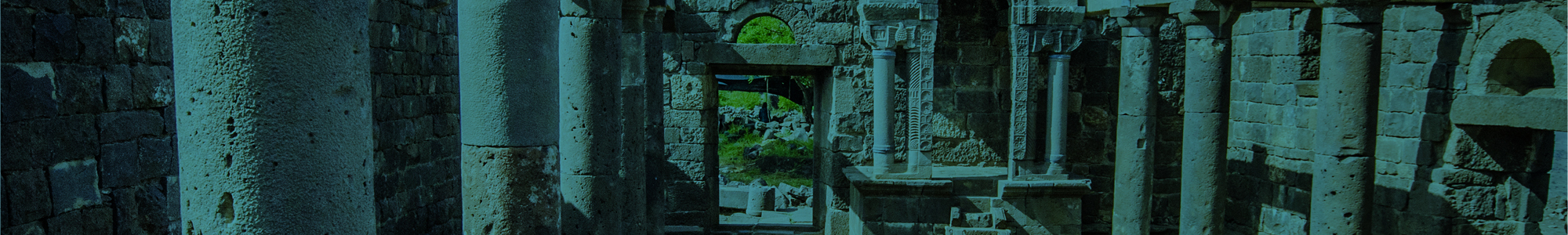
Ein Keshatot
In the center of the ancient village, a 6th century synagogue from the Byzantine Period was reconstructed, and it features an Ark Complex that is the most complete and the most preserved ever discovered in Israel. The ancient ark area includes high-quality engravings of a Menora (candelabra), a Lulav (palm branch), an Etrog (citron), a grapevine, and more. On the other side of the village are ancient arches that stand above a spring, whose waters flow into pools. The village spring is what gave the site its name: Ein Keshatot means “Spring of the Arches” and in Arabic it is called Um el-Kanatir (“Site of the Arches”). The site is not directly on the Golan Trail, but very close to it. There is an entrance fee to the site (which includes a movie).


The Riverbed Intersection
At this spot, the El-Al Riverbed flows into the Samekh Riverbed as its main tributary and one of its main sources of water. The junction of the two riverbeds creates beautiful secluded spots with natural pools.
Visiting Ein Keshatot
During your visit to Ein Keshatot (previously known as Um el-Kanatir), you will find a beautiful visitor center with a movie that explains the story of the site. You can visit the arched spring that gave the Um el-Kanatir its name, as well as the impressive ancient synagogue that was rebuilt stone-by-stone, using a unique modern technology for its reconstruction. Don’t miss this site!


